The introduction of the new DToF (Direct Time of Flight) sensor, featuring a remarkable 500Hz single point LiDAR system, marks a significant advancement in drone technology. With the ability to provide high-frequency, precise measurements, this innovative sensor is poised to enhance various applications across industries, from agriculture to infrastructure inspection. By offering improved depth perception and operational efficiency, the DToF sensor not only addresses the limitations of traditional LiDAR systems but also opens new avenues for data collection and analysis. As drones continue to revolutionize how we approach surveying and monitoring tasks, understanding the capabilities and implications of this cutting-edge technology becomes essential.
Overview of DToF Sensor Technology
What is DToF Technology?
DToF, or Direct Time of Flight, is like the cool cousin of traditional LiDAR technology. Instead of bouncing a laser beam off surfaces and measuring the return time, DToF sensors emit light pulses and directly measure how long it takes for the light to go to an object and come back. This clever method allows for quick and precise distance measurements—a bit like a laser tag game where you always know who's winning!
How DToF Sensors Work
DToF sensors operate by sending out thousands of light pulses per second (in this case, 500Hz) and measuring the time it takes for each pulse to return after bouncing off an object. By calculating the distance based on this time delay, the sensor builds a 3D map of the environment. Think of it as your drone’s own set of eyes, constantly scanning and mapping the world around it, allowing for fast and responsive navigation.
Key Features of the 500Hz Single Point LiDAR
High Frequency Sampling Rate
With a sampling rate of 500Hz, this LiDAR can capture data points five hundred times a second! This means faster and smoother data acquisition, allowing drones to accurately map environments and navigate obstacles without breaking a sweat (or a propeller).
Compact Design and Weight Considerations
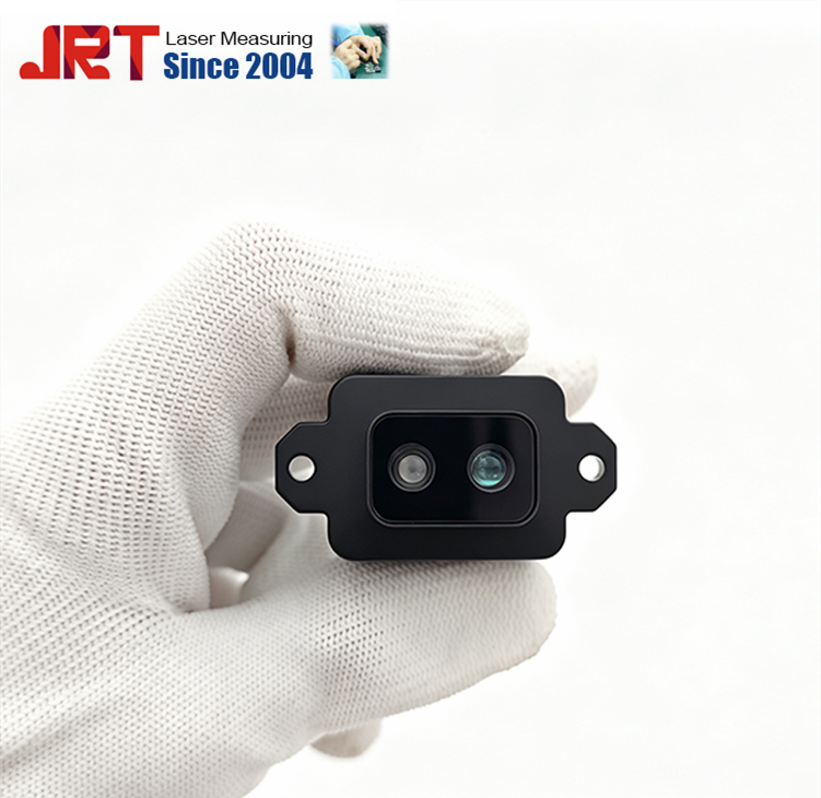
Weighing in at a featherlight size, the 500Hz single point LiDAR is designed with drones in mind. It’s like the minimalist of sensors—sleek, efficient, and easy to mount, ensuring that your drone doesn't need to hit the gym to carry it. Less weight = more flight time, and who wouldn’t want that?
Real-Time Data Processing Capabilities
This LiDAR doesn’t just collect data; it processes it in real-time, turning raw information into actionable insights faster than you can say “enhanced aerial mapping.” Whether you're tracking changes in terrain or detecting obstacles, you can trust this sensor to deliver timely information, making it a vital companion for any flying adventure.
Advantages of LiDAR for Drone Applications
Enhanced Depth Perception
LiDAR gives drones the superpower of depth perception, allowing them to understand their surroundings in three dimensions. This means that navigating complex environments, like forests or urban landscapes, becomes less of a guessing game and more of an expertly choreographed dance.
Improved Accuracy and Precision
Unlike your favorite uncle who can never quite tell the time, LiDAR systems are all about accuracy. They deliver precise distance measurements, which is especially useful when you’re surveying land or mapping out spaces that require high fidelity. Basically, it’s the sensor equivalent of a Swiss watch—reliable and always on point.
Operational Efficiency in Various Conditions
Rain or shine, day or night, LiDAR shines in varying conditions where traditional cameras may struggle. Its ability to penetrate fog, dust, and even light rain allows drones to operate efficiently in environments that would leave other sensors feeling a little lost. Think of it as the trusty raincoat for your aerial adventures.
Comparison with Traditional LiDAR Systems
Cost-Effectiveness
The 500Hz single point LiDAR system is not just a fancy gadget; it’s also gentle on the wallet! Compared to traditional LiDAR systems that can cost as much as a small car, this new tech brings cutting-edge capabilities to the table without breaking the bank. More bang for your buck? Yes, please!
Performance Differences
When stacked against traditional LiDAR, the DToF sensor offers rapid data acquisition and real-time processing that can leave older systems in the dust. It’s like comparing a sports car to a tricycle—both can get you from point A to B, but one definitely gets you there faster and with more style.
Size and Integration Considerations
Traditional LiDAR systems often come with cumbersome hardware, but the compact design of the new DToF sensor makes it easy to integrate into various drones. It’s like fitting a high-performance engine into a tiny go-kart, maximizing capability without sacrificing the sweet freedom of flight.
Potential Use Cases in Various Industries
Agriculture and Crop Monitoring
The agriculture sector is about to level up, thanks to the new DToF sensor! With its 500Hz single-point LiDAR capability, farmers can now monitor crop health with laser precision. Picture this: from the comfort of your cozy chair, a drone is zipping around your fields, gathering robust data on crop conditions, water levels, and potential pest infestations. It's like having a farm consultant that won't take coffee breaks!
Infrastructure Inspection
Infrastructure inspection is another hot spot for our DToF sensor buddy. Think of it as a super-powered set of eyes for detecting cracks in bridges, uneven pavement, or rogue power lines. With the ability to capture detailed 3D models and high-resolution data, drones equipped with this tech can help inspectors identify issues before they escalate, saving a ton on repair costs (and a headache or two).
Environmental Surveys and Research
In the world of environmental research, the DToF sensor is poised to make waves. Researchers can conduct detailed surveys of forests, wetlands, and coastal areas without leaving a trace (well, other than the drone, but who’s counting?). This advanced LiDAR technology allows for assessing biodiversity, tracking shoreline changes, or even monitoring climate change effects—all while collecting data that’s more accurate than your neighbor’s DIY home project.
Technical Specifications and Performance Metrics
Range and Resolution
When it comes to range and resolution, the DToF sensor is flexing some serious muscles. With the ability to measure distances accurately in a variety of environments, it boasts a robust operational range that can effectively cater to both wide-open fields and dense urban jungles. Plus, the resolution is so sharp you might mistake it for high-definition television—but instead of binge-watching, you're all about those precise distance measurements.
Power Consumption and Battery Life
Just because it’s powerful doesn’t mean it’s a battery guzzler! The DToF sensor is designed with efficiency in mind, ensuring that drones can operate for extended periods without urgently seeking a charging station every hour. This balance of power consumption and battery life means longer missions and fewer interruptions—because who wants to cut a scenic drone flight short for a pit stop?
Data Output Formats and Compatibility
Data compatibility can be a tangled web, but the DToF sensor makes it easy-peasy. It supports a range of data output formats, meaning it can play nice with different software for data analysis and mapping. Whether you're using it to create stunning visual reports or raw data for your nerdy number-crunching needs, the sensor has got your back—like a trusty sidekick in the world of data!
Future Developments in LiDAR Technology
Advancements in Sensor Technology
As the world of LiDAR technology evolves, get ready for more mind-blowing advancements in sensor technology. Expect improvements in sensitivity, miniaturization, and perhaps a dash of sci-fi magic—who wouldn’t want a sensor that can detect the exact mood of a tree? These next-gen sensors will be even more powerful and versatile, paving the way for innovations we can only dream up (or watch in a movie).
Integration with AI and Machine Learning
The future is all about AI and machine learning, and LiDAR is no exception! By integrating these advanced technologies, DToF sensors will soon be able to analyze data on-the-fly, offering real-time insights that are smarter than your average bear. Picture a drone that not only sees but also understands, predicting potential problems before they even arise. Sounds like something straight out of a tech thriller, right?
Trends in Drone Applications
With the growth of DToF sensors, we’re seeing some exciting trends in drone applications. From delivery drones that can navigate complex urban environments to drones that monitor wildlife populations, the possibilities are as endless as the sky itself! As we embrace these new technologies, expect to see drones taking on roles that were once the stuff of dreams—like your own personal drone assistant (who, let’s be honest, will probably still need some serious human supervision).
Conclusion: Impact of DToF Sensors on Drone Innovation
Summary of Key Benefits
To sum it all up in a tidy little package, DToF sensors are game-changers for drone technology. With their high-frequency capability, impressive range, and versatility across various industries, they’re set to revolutionize how we collect and analyze data. The days of guessing are gone—welcome to the era of informed decisions with accuracy that even a perfectionist would approve of!
Looking Ahead: The Future of Drone LiDAR Technology
As we look to the future, the impact of DToF sensors on drone innovation is only just beginning. With continuous advancements and integrations with AI, the sky’s the limit (literally!). It's an exciting time for drone enthusiasts, researchers, and businesses alike, as we gear up to welcome smarter, more capable drones that will redefine how we interact with our world. Buckle up—it's about to get thrilling!In conclusion, the introduction of the 500Hz single point DToF LiDAR sensor represents a pivotal leap forward in drone technology, offering enhanced accuracy, efficiency, and versatility for a wide range of applications. As industries increasingly adopt this innovative sensor, the potential for improved data collection and analysis will continue to grow. Embracing these advancements will not only streamline operations but also pave the way for future innovations in the field of drone technology.
Frequently Asked Questions (FAQ)
What advantages does the 500Hz DToF LiDAR sensor offer over traditional LiDAR systems?
The 500Hz DToF LiDAR sensor provides a higher sampling rate, allowing for more accurate and real-time data capture. It is also designed to be more compact and lightweight, enhancing the overall efficiency of drone operations.
How can the DToF sensor be utilized in agriculture?
In agriculture, the DToF sensor can be used for crop monitoring, allowing farmers to assess plant health, optimize resource use, and improve yield by providing precise data on field conditions.
What types of industries can benefit from this new LiDAR technology?
Various industries can benefit from the DToF LiDAR technology, including agriculture, infrastructure inspection, environmental research, and surveying, as it enhances data collection capabilities across these sectors.
Is the DToF sensor compatible with all drone models?
While many drones can integrate DToF sensors, compatibility may vary based on the drone's design and specifications. It is important to check the manufacturer's guidelines for specific integration requirements.
Chengdu JRT Main Range Modules: Industrial Laser Distance Sensors, Outdoor Rangefinder Laser Module, Tof LiDAR Sensors, New Arrivals Laser Rangefinder Module.